Maps
Go Dig A Hole, Mister
Wayfinding in the age of fully-formed cartography isn't too terribly difficult. With land maps evolving daily through satellite imagery and networked resources online, we are never really at risk of being lost (unless the batteries in our GPS run out). From a get-there-from-here perspective, all the answers to all the questions seem to be answered. What else is there to conquer?
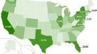
Map nerd alert: hot hybrid states
If you happen to be a map nerd, this will surely interest you: a US map that shows how hybrid sales cars are doing. The only problem is that the map only shows absolute values, but the page also shows the ratios for the 15 states with the most hybrids per capita. It's no surprise that the number of cars sold in states such as California, New York, Florida, Texas and Illinois, being the most populous states in the Union, are the states where the most hybrids were sold.
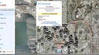
Avoid traffic and save fuel - Google Maps now shows you the traffic to avoid
There's nothing worse than sitting in traffic, especially knowing that your vehicle, and all those around you, are contributing to carbon emissions while achieving next to nothing in terms of useful work. The ideal situation of course is to avoid the traffic jams in the first place and most modern satellite navigation systems are helping to do that. But for everyone else with access to a web browser and a moment's spare time before heading out the door to work in the morning, Google is out to he
.jpg)
GPS system for bicyclists
A common charge car drivers hurl at GPS systems is that they're unnecessary for anyone with maps and the brains to use them. But what about cyclists using unfamiliar bike lanes? The Dutch cyclists union ENFB has started a volunteer effort to map the numerous bike lanes for GPS, many of which are inaccessible by cars and thus not used by navigation companies like Navteq. States project leader Kees Bakker, "This is really a Dutch problem. Other countries have very few dedicated bike lanes and in t

"At the next boulder, turn right off cliff"
Technology is wonderful. Technology is also made or, in this case, programmed by people.