
Featured Gallery

The sun goes down on Battle Rock, Port Orford, Oregon, and my time on the Trans-America Trail. I was as filthy as the Jeep.
Jonathon Ramsey
A special mention to the folks running the Bighorn RV Park and Campground in Coaldale, CO. A whole lot nicer than a lot of places I stayed, and for less money, and the owners were excellent to me.
Jonathon Ramsey
Another benefit of Bighorn? Hop into Salida (pronounced suh-LIE-duh) and get a Fiesta Burrito at Fiesta Mexicana. A local recommended it, and she did not steer me wrong.
Jonathon Ramsey
Dip into southeastern Utah from Colorado, get past Monticello, and it’s desert farms and rickety fences under big skies and ever-distant mountains.
Jonathon Ramsey
Then climb up to high plains on the way to Geyser Pass. This is the *other* Utah.
Jonathon Ramsey
Take the back way up to Geyser Pass and you’ll find some impressive boulder fields. It was kinder on everyone to leave just two wheels in the rocks and put the other two anywhere else.
Jonathon Ramsey
Another reason why the Jeep and its ilk are the right size for deep backcountry work. I probably could have gotten a full-sized truck through this patch of trees, but neither the truck nor the trees wouldn’t have looked the same when I was finished.
Jonathon Ramsey
The trail opens up, and you can see the target in the distance. Somewhere up there was Geyser Pass. In between here and there were a lot of rocks, dirt, serious holes, and roads that weren’t on any map.
Jonathon Ramsey
Coming down the pass, a pullout offers a grand view of the Spanish Valley. Moab’s down there – Jeep City, USA. And see those clouds? A storm’s a-comin’. *Another* one.
Jonathon Ramsey
Ah, there’s the place. This was not far from Slickrock. I wanted to do the trail, but a Biblical deluge beat me to it.
Jonathon Ramsey
I got out of the Moab storm and far away. As I headed to the next town, I saw this one coming in…
Jonathon Ramsey
This is what it looked like on I-70 West. I wasn’t even going five miles per hour. And I was passing other vehicles on the highway who were going slower than I was.
Jonathon Ramsey
The reward for making it to Salina? A DOUBLE RAINBOW!! WHAT DOES IT MEAN??!!
Jonathon Ramsey
After Salina I climbed up into Fishlake National Forest. More high plains. More grazing cattle. More gorgeous.
Jonathon Ramsey
The further west I got, the more times I had to turn around. The trail was designed by motorcyclists, for motorcyclists. So this time, in Fishlake, the trail got too narrow for the Jeep to pass.
Jonathon Ramsey
Cows normally scurry out of the way. Not this one, who stood in the trail, looked at me like I’d clearly made a wrong turn, and silently suggested I turn myself around and go back where I came from.
Jonathon Ramsey
We settled our differences and he let me past, into some lush stands of greenery.
Jonathon Ramsey
West of Sevier, UT on the way to the Nevada border, the trail leaves the mountains behind for golden plains.
Jonathon Ramsey
Blackrock Road, still hauling Utah and Colorado filth. Jeep engineers found a way to get mud thrown by the front tires to stick behind the door handles and dry there, so my hands always looked as dirty as the Jeep.
Jonathon Ramsey
If you ever need to outrun Armageddon, Blackrock Road’s a great place to start. Huge speed for huge miles, huge rooster tails of dust.
Jonathon Ramsey
Just more Utah, this time not far from the Nevada border and the city of Baker.
Jonathon Ramsey
And more Utah, because… well, look at it.
Jonathon Ramsey
Saw this in Baker, NV. I can see the ad now: “No lowball offers, I know what I’ve got. And no tire kickers.”
Jonathon Ramsey
Across the road from that Jeep, this place. Know what that sign says?
Jonathon Ramsey
MUSEUM OF THE FUTURE! Coming soon. Soon-ish.
Jonathon Ramsey
Like, I wouldn’t wait around for it to open…
Jonathon Ramsey
In fact, you might want to give it a while. How about we call you when it’s ready? In the, uh, future…
Jonathon Ramsey
There’s a stretch of US-50 in East Ely, Nevada that bills itself “The Loneliest Road in America.” But make a right turn onto the dirt road, and it gets mighty lonely out there.
Jonathon Ramsey
Didn’t take long for the trail to turn into sandy powder. I made impressive clouds of the stuff on the way to Lund, NV.
Jonathon Ramsey
I also made an impressive mess in the back. Like I said before, two tiny cracks between the soft top panels only let in a wisp of sand, but when you do as much high-speed sand driving as I’ve been doing, the layers add up.
Jonathon Ramsey
Scorched Nevada hills. While I waited, two helicopters flew in to deliver fire crew assistance.
Jonathon Ramsey
The haze from the Oregon fires. There’s a mountain range on the right. On the left, a billboard asking people not to start forest fires.
Jonathon Ramsey
Not long after, the haze got worse. Couldn’t see a thing in the distance, but there are more mountains back there.
Jonathon Ramsey
So I stopped to check out the only thing I could see, and paid tribute to Popsicle.
Jonathon Ramsey
Starting in North Carolina, I’ve seen a lot of collections of… curiosities, shall we say?… in a lot of people’s yards. I’ve seen “antique” shops that sold all kinds of signs. But never had I seen a place with a nine-foot-tall Shell sign…
Jonathon Ramsey
The big sign even had a little brother. Trivia sidebar: the shell on the sign is called the ‘pecten,’ which is a genus of large scallops or clams. And Shell has been a godsend, since they gave me a stack of gas cards to keep it moving for this whole trip. But even I’m not buying giant signs.
Jonathon Ramsey
What I could see of eastern Oregon through the haze, as with so much of the trail I’d been through already, was beautiful.
Jonathon Ramsey
But this is when I went from wildfire haze to actual wildfires. And even more U-turns and detours.
Jonathon Ramsey
On a ridge above Glendale, Oregon heading into what I thought would be an easy 114-mile celebratory parade into Port Orford. Moments after I took this photo, things went south. Way south. First came an hour’s worth of finding my way out of a maze of unmapped trails.
Jonathon Ramsey
Then came more wildfires. As I picked my way through nearby fires, I had this one in the distance to look forward to.
Jonathon Ramsey
Then came The Peak of Fallen Trees.
Jonathon Ramsey
Trees everywhere. With no obvious reason for having fallen.
Jonathon Ramsey
I picked my way through all I could. It doesn’t look like it, but this one was too big to drive over, so I worked the winch for the first time.
Jonathon Ramsey
Turned out to be lucky for me. Whoever had the Jeep before I did had wound the winch cable so badly that I couldn’t pull it out. I had to use the weight of the tree to unspool the line.
Jonathon Ramsey
I cleared the path. After this would come 90 more minutes of winching, some axe work, crawling through strewn trunks, and then…
Jonathon Ramsey
Rocks. They were a bigger problem than the trees, but I could have got through them…
Jonathon Ramsey
Only it would have been useless. A bit further down the trail, a chunk of mountainslide had come down. The trail was closed. At least I knew what I was facing on the way back, like the trees and…
Jonathon Ramsey
Another wildfire. The Oregon National Guard had been called in to help with this one.
Jonathon Ramsey
At *************** last, I got to Port Orford and some fish and chips. Then I filled up and headed north. And just as I pulled out, it rained.
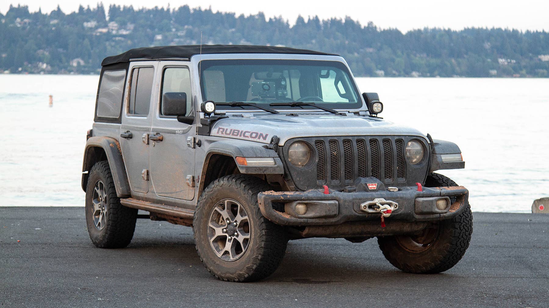
Jonathon RamseyOur man Jonathon Ramsey is driving a Jeep Wrangler Rubicon on a 14-week, 14,000 mile journey across North America. Check out his first, second, and third installments.
Port Orford, Ore. – On arrival at Battle Rock, just off the southern coast of Oregon, I had completed the (other) Trans-America Trail. It’s a worthy Bucket List endeavor even before you get to the bits that challenge a Jeep Wrangler Rubicon. The first tests came in western Oklahoma, tiptoeing through and around swampy farmland. Once I got to Colorado, the difficulty scale increased with each day’s driving. By the time I hit wildfires and constant detours in Oregon, I was ready for the trail to end. Here are a few more notes from the last half:
- When I filled up in Columbia, North Carolina just before getting to Oregon Inlet, the odometer showed 12,294 miles. When I filled up in Port Orford before heading north to Seattle, the odo read 18,008, for nearly 6,000 miles in three weeks. GPSKevin says his trail covers 5,184 miles, but detours are an unavoidable part of the experience.
- Utah wins my vote for the widest variety of beauty. Crossing into southeastern Utah from Colorado, the landscape is full of desert farms and endless visibility to mountains at the ends of the Earth in Monticello. It’s plush high plains greenery on the way up and down Geyser Pass, then the rocky red pioneer-killing cauldron of The Spanish Valley and Moab. Scrub-filled rock formations stretch to Salina, then back up to verdant forests in both halves of Fishlake National Forest. A final rocky stretch west of Sevier, Utah fell into a rolling golden land past Black Rock, another trip into sparer mountains, then the final comedown to Baker, Nevada. Moab gets all the Jeep love, but there’s plenty of fun all over the state.
- In Ely, Nevada I met a Harley rider headed east out of Oregon who told me, “It’s all on fire. Whole state. On fire.” The haze began not long after leaving Ely. By the time I departed Battle Mountain, Nevada hills showed their own scorched-earth scars, and science-fiction gray skies hid entire mountain chains. Detours were already longer and lengthier in the West because of closed roads, locked gates, and “No Tresspassing” signs. Now fire-centric detours and turnarounds joined the routine.
- The last day on the trail in Oregon, a 114-mile route from Glendale, through the Rogue River Siskiyou National Forest to Port Orford, was the hardest. Because the TAT runs though working logging areas, whole trail roads disappear. In the mountains above Glendale I had to pick my way out of a maze on trails that didn’t show up on my Garmin nor on the Jeep’s navigation. Later, about 20 miles from the end of the trail, I ran into The Peak of Fallen Trees – thick timbers lie across the trail for no obvious reason. I spent two hours winching trunks out of the way, chopping a couple in half with My Mighty Axe, and picking my way over and through the rest. Then I got to the rocks, where a chunk of mountainside had slid into the road. That was the end of the TAT for me. I had to turn around and find the long way out, an 80-mile detour run with a light foot on a low tank of gas.
- I met fewer folks in the west, yet as in the east, everyone was memorably kind. In Coaldale, Colorado I stayed at the Bighorn RV Park and Campground, recently purchased by an industrious family who – as far as I could tell – just wanted something else to succeed at. They already run a successful farm in Elkhart, Kansas, have a small Airbnb operation, and led the effort to bring industrial hemp farming to Kansas as a way to conserve water and promote sustainable industrial goods. They were also thoroughly kind-hearted and attentive, even as their personal home in the canyon above the park was threatened by flooding severe enough to wash away cars.
- The hamlet of Lakeview, Oregon is the perfect setting for a sequel to the movie Roxanne. I camped at the fairgrounds and met Kerry, who’d brought his Les Schwab company truck to get a whole lot of water. His wife wanted a proper lawn, and the grass wasn’t coming up easy. When he wished me good luck on my trip, I said I think my trip is easier than his Green-Thumb-ing. After giving me the skinny on where to eat, he explained that Lake City’s in a dark zone, and gave me directions to a nearby mountain to check out the night skies. The next morning I met Heidi, who suggested the Roxanne similarities. A former East Coast designer with a resume that includes the latest Viewmaster, she gave up all the NYC rat race to become a rural appraiser, driving a Chevy Silverado with a camper kitted out as a mobile office. We met when she asked me if my water was brown, too; the whole city had brown water that morning and no one had any idea when it would be fixed. Because Roxanne. While workers built the rides for coming fair in the paddock next to us, my long chat with Heidi about the big city and the big country included her tale of meeting “The Mayor of Nasty Flats” – a real person, a self-appointed title, his nicknamed suburb. Because Roxanne.
- If you want to try the Trans-America Trail, there are two ways I know of. The hardest, which I don’t recommend, is downloading the GPX track from the Internet. My guess is that it’s one of the first tracks Sam Correro made, when the TAT route was free. But the TAT is a living thing, changing every year. My maps are from 2016 and need plenty of revision. The much easier way is to purchase maps from either Sam Correro for the original TAT, or GPS Kevin. Correro’s maps are more expensive – the entire set costs $234, portions run from $8 for just an SD card to $28 for roll charts and the lot. I paid $42 for the other TAT bundle from GPSKevin, including an SD card, and small and large maps breaking the journey into day-sized bites.
- The Jeep’s still a goer, but it’s feeling lived in. Something rattles mildly under the vehicle on the driver’s side. I hear the tiny creaking of a tiny spring in the driver’s seat belt tensioner. In the cargo area, it sounds like a piece of hard plastic trim bangs against the sheetmetal when I hit a big bump, but I can’t locate the source. I emptied the cargo area and found a bolt, but I couldn’t figure out where the bolt belonged. At a gas station I opened the driver’s door to its stops. When I got in and pulled the door closed, I heard the unmistakable sound of two glued panels just beginning to pull apart. Nothing major, but the door armrest doesn’t appreciate how much I pull on it.
- The LED headlights work fine, but a good portion of oncoming traffic thinks the low beams are brights. I wasn’t using the brights because they don’t throw light further down the road. Instead, for reasons I can’t fathom, they light up the upper portion of the landscape. Now I use the brights so I can make a show of turning them off, and oncoming drivers know I’m not thoughtlessly trying to blind them.
- The trail took so long that I’m skipping the Alaska sightseeing I had planned – I’m ready to get into driving that needs a Wrangler. From here I’ll skedaddle to Seattle, reorganize and get an oil change, then shoot up through British Columbia and the Yukon to Fairbanks and Deadhorse. After one look at the Bering Sea, I’ll turn around and race back to British Columbia and line myself up at one of the serious Canadian trails – I’m thinking MacKenzie.
Then we’ll taste blood. Hopefully not mine. Or not too much of mine, at least.